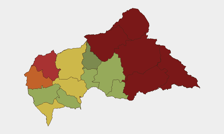
Situation Summary
Central African Republic remains at elevated risk (global rank #33, composite score 65), with conflict and armed group activity as the primary threat drivers. A major artisanal gold mine collapse near Baboua on 2026-08-18 to 2026-08-20 has claimed over 100 lives and resulted in formal mine closure, shifting immediate humanitarian and occupational safety concerns to the forefront. The security environment across eastern and northern prefectures remains volatile due to ongoing armed group presence and competition for resource zones. No significant security incidents (armed clashes, attacks) were reported in the last 24–48 hours.
Key Developments
- Zamboye/Baboua artisanal gold mine collapse (2026-08-18 to 2026-08-20) — A subsurface collapse at an informal mining site near the Cameroon border killed more than 100 miners; rescue operations encountered ongoing instability and flooding. Seven injured were transported ~50 km west to Baboua hospital. [Reuters, AFP, AP, Africanews]
- Mine closure order (2026-08-21) — Authorities shut the Zamboye mine following the disaster, reflecting formal regulatory response to occupational hazard and casualty event. [Africanews]
- No corroborated armed-group or conflict events in last 48 hours — Web research identified no cross-sourced incidents of armed clashes, attacks on civilians, or military operations with clear 24–48-hour dating.
Highest-Risk Areas
Vakaga (95), Bamingui-Bangoran (92), and Haute-Kotto (88) in the northeast and east represent the highest-risk prefectures, driven by persistent armed group presence, competition for control of diamond and gold zones, and limited state authority. Bangui (78) and surrounding Ombella-M'Poko (62) remain moderately elevated due to sporadic crime and occasional inter-communal tension. Western and southwestern prefectures (Ouham-Pendé, Nana-Mambéré, Sangha-Mbaéré) are less acutely threatened by conflict but carry residual risks from cross-border activity and informal resource extraction hazards (as evidenced by the recent mine disaster in Ouham-Pendé).
How GeoBit Would Assist
Security teams operating in or monitoring CAR would prioritize AOI Monitoring & Early Warning on high-risk prefectures (Vakaga, Bamingui-Bangoran, Haute-Kotto) and border zones to detect armed-group movement or clashes. Intel Sweep and multi-language OSINT (including Telegram, local radio, and regional media) would provide continuous signals of resource-competition escalation, displacement, or insurgent activity. GIS & Spatial Analysis and Satellite & Imagery would support site assessment of mining operations, checkpoints, and supply-route security for corporate assets in resource zones.
7-Day Outlook
No imminent escalation in armed conflict is signaled for the immediate week; security risk remains chronic rather than acute. Continued focus on occupational and humanitarian response to mine-collapse casualties will occupy national and international attention. Baseline vigilance on armed-group activity in northeastern prefectures and cross-border incursions should remain elevated through routine monitoring.
Highest-Risk Areas — Ranked
| # | State / Region | Risk |
|---|---|---|
| 1 | Vakaga | 95 |
| 2 | Bamingui-Bangoran | 92 |
| 3 | Haute-Kotto | 88 |
| 4 | Haut-Mbomou | 85 |
| 5 | Mbomou | 82 |
| 6 | Ouham-Pendé | 79 |
| 7 | Bangui | 78 |
| 8 | Nana-Mambéré | 75 |
| 9 | Sangha-Mbaéré | 68 |
| 10 | Ouham | 65 |
| 11 | Ombella-M'Poko | 62 |
| 12 | Kémo | 58 |
Sources
Previous Daily Briefs
A new Central African Republic brief is written every day — each with its own risk map and downloadable CSV. Here's the last week; use the calendar to go further back.
- August 23, 2026
- August 21, 2026
- August 20, 2026
- August 19, 2026
- August 18, 2026
- August 17, 2026
- August 16, 2026
📅 Browse every day by calendar →
Highlighted days have a brief. Tap a day for that day's map & analysis, or “csv” for that day's dataset ($5).
Atlas — our AI intelligence desk — emails them this snapshot personally. Nothing else, no list.