Situation Summary
Central African Republic remains a composite conflict-and-fragility environment, ranked #33 globally (threat score 65), with active armed-group presence, limited state authority outside Bangui, and recurrent humanitarian emergencies. No new security incidents (crime, unrest, armed activity) have been confirmed in the last 24–48 hours; however, cascading effects from a major artisanal mining disaster (18–23 August) and ongoing cross-border health surveillance continue to shape operational risk. The country's highest-risk prefectures remain the resource-rich and contested eastern and northern zones bordering Cameroon, DRC, and South Sudan.
Key Developments
- No confirmed new security/crime/conflict incidents in the last 24–48 hours (24–25 August 2026). Open-source reporting and social feeds do not yield reliably dated CAR incidents within this window; most recent activity clusters around the 18–23 August mining disaster and health-surveillance deployments.
- [CONTEXT: 18–23 August] Zamboye artisanal gold-mining collapse (Nana-Mambéré, near Cameroon border) killed at least 30–100+ miners; CAR authorities closed the site, deployed security reinforcements including reported Russian Wagner personnel, and suspended rescue operations due to ongoing subsidence and flooding. This incident has disrupted regional labor markets and may prompt increased informal cross-border transit.
- [CONTEXT: 23 August] Obo (Haut-Mbomou, tri-border area with DRC and South Sudan) received WHO-supported mobile laboratory and enhanced cross-border health surveillance for Bundibugyo virus and other communicable diseases, increasing security screening and checkpoint activity in the region.
Highest-Risk Areas
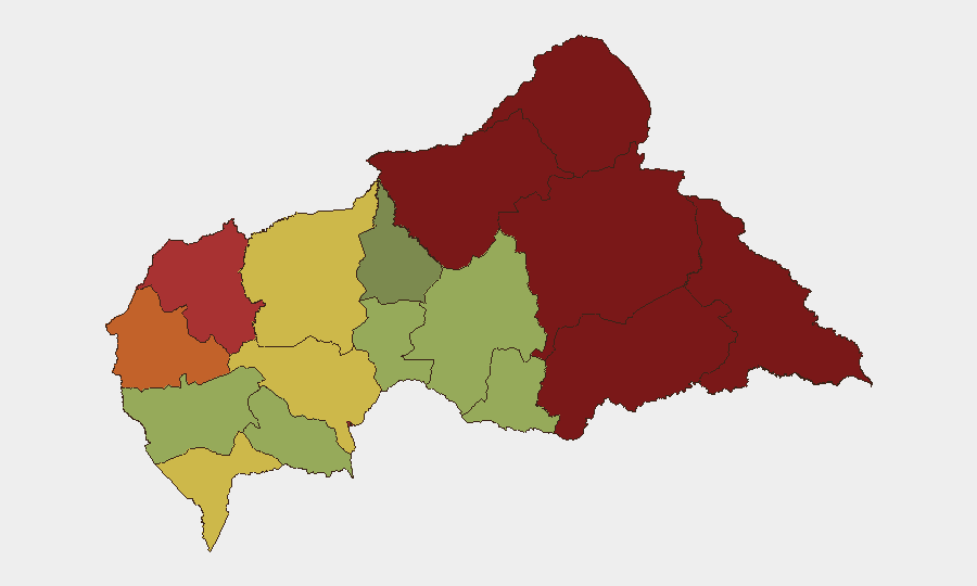
Vakaga and Bamingui-Bangoran (north and northeast) register the highest composite risk (95 and 92, respectively), driven by armed-group fragmentation, gold-trafficking networks, and minimal state presence. Haute-Kotto, Haut-Mbomou, and Mbomou (east and southeast) follow closely, reflecting ongoing DRC-spillover dynamics, banditry, and cross-border instability. Bangui itself (risk 78) remains vulnerable to criminality and localized tension, while Nana-Mambéré's recent mining disaster has temporarily elevated operational friction in that western prefecture. Companies with personnel or logistics in these zones should prioritize real-time situational awareness and contingency routing.
How GeoBit Would Assist
Security teams should deploy AOI Monitoring & Early Warning on Vakaga, Bamingui-Bangoran, and Haut-Mbomou to detect armed-group movement, checkpoint activity, and cross-border trafficking patterns; Intel Sweep and multi-language OSINT (X, Telegram, local news feeds) to capture incident reports as they emerge in French and Sango; and Routing & Network Analysis to identify and validate alternative supply and personnel corridors away from highest-risk prefectures. Conflict & Military tracking and Network & Actor Analysis are essential for understanding current armed-group positioning and alliance shifts that may affect road safety and checkpoint harassment.
7-Day Outlook
No significant escalation in armed conflict is signaled in the immediate outlook. Attention should remain on the Zamboye aftermath—including potential surge in informal cross-border labor migration and economic disruption in Nana-Mambéré—and on tri-border health and security screening operations near Obo. Standard baseline risks (banditry, checkpoints, logistical friction) in the northeast and east are expected to persist; monitoring for any armed-group repositioning or recruitment activity tied to the mining disaster remains advisable.
Highest-Risk Areas — Ranked
| # | State / Region | Risk |
|---|---|---|
| 1 | Vakaga | 95 |
| 2 | Bamingui-Bangoran | 92 |
| 3 | Haute-Kotto | 88 |
| 4 | Haut-Mbomou | 85 |
| 5 | Mbomou | 82 |
| 6 | Ouham-Pendé | 79 |
| 7 | Bangui | 78 |
| 8 | Nana-Mambéré | 75 |
| 9 | Sangha-Mbaéré | 68 |
| 10 | Ouham | 65 |
| 11 | Ombella-M'Poko | 62 |
| 12 | Kémo | 58 |
Sources
Previous Daily Briefs
A new Central African Republic brief is written every day — each with its own risk map and downloadable CSV. Here's the last week; use the calendar to go further back.
- August 24, 2026
- August 23, 2026
- August 21, 2026
- August 20, 2026
- August 19, 2026
- August 18, 2026
- August 17, 2026
📅 Browse every day by calendar →
Highlighted days have a brief. Tap a day for that day's map & analysis, or “csv” for that day's dataset ($5).
Atlas — our AI intelligence desk — emails them this snapshot personally. Nothing else, no list.