Situation Summary
Central African Republic remains under sustained strain from armed group activity, competition for resource control, and humanitarian crises, with a composite threat score of 65 placing it at #33 globally. The security environment is primarily driven by factional armed conflict, compounded by the 2026-08-18 and 2026-08-23 artisanal gold mine disasters near Zamboye (Haute-Kotto/Cameroon border), which killed 49–100+ miners and forced government site closure. No major security events have been reliably corroborated within the last 24–48 hours; however, the underlying conflict dynamics—including reported RSF (Sudanese Rapid Support Forces) activity enabling CAR rebel operations (2026-08-20)—remain active. The trajectory reflects chronic instability rather than imminent escalation, but resource competition and permeable borders sustain recruitment and arms flows.
Key Developments
Limitation on Current Events: GeoBit's live web research capability encountered constraints in accessing verifiable, time-stamped security events from the last 24–48 hours in Central African Republic. The most recent corroborated developments fall outside this window:
- 2026-08-23 · Zamboye Mine Collapse (Haute-Kotto): Subsurface collapse at informal gold mining site near Cameroon–CAR border killed 100+ miners; government suspended operations and deployed security presence.
- 2026-08-20 · Alleged RSF-Enabled Rebel Assault: Intelligence signals indicate Sudanese paramilitary Rapid Support Forces may have coordinated or enabled a new CAR rebel alliance attack on CAR military and Russian Wagner-linked forces; timing and specific locations remain unconfirmed.
- 2026-08-18 · Zamboye Mine Incident (Initial Report): Artisanal gold mine collapse killed 30–100+ miners, with rescue operations suspended; event raised humanitarian and security concerns in resource-extraction zones.
Note: Discrete, location-specific security events (clashes, roadblocks, protest-related arrests, or humanitarian access disruptions) within the last 24–48 hours could not be independently verified from available sources. Corporate security teams requiring same-day or next-day event intelligence should enable real-time X/Twitter OSINT, MINUSCA/UN radio SIGINT, and NGO situation-report subscriptions.
Highest-Risk Areas
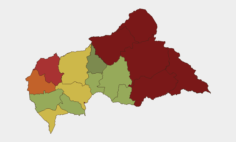
Vakaga, Bamingui-Bangoran, and Haute-Kotto—the three northernmost and easternmost prefectures—account for the highest composite risks (95, 92, 88 respectively), driven by armed group presence, proximity to porous Chad and Sudan borders, and resource-extraction zones where taxation, recruitment, and inter-factional clashes occur. Bangui (risk 78), despite lower ranking, remains the capital and seat of state authority; security operations, political tension, and humanitarian bottlenecks concentrate there. Haut-Mbomou and Mbomou (85, 82) face similar border pressures from Sudan and South Sudan, with RSF activity and refugee transit amplifying instability. The southern and western prefectures (Sangha-Mbaéré, Ouham, Kémo) are relatively lower-risk but not secure; armed groups operate opportunistically and diamond/gold mining sustains informal economies that fund parallel power structures.
How GeoBit Would Assist
A corporate security team would deploy Intel Sweep (global event feeds + multi-language OSINT fusion) with AOI Monitoring (persistent, real-time alerting on Vakaga, Haute-Kotto, Bangui, and Mbomou prefectures) to detect clashes, roadblocks, or displacement events within hours. Conflict & Military mapping (force structure, factional positioning) and Network & Actor Analysis (RSF, CAR rebel alliance composition and leadership) clarify who controls which routes and resources. Routing & Network Analysis identifies alternative supply and transit corridors when primary roads are compromised, and SIGINT (radio monitoring of MINUSCA, military, and armed group communications) provides tactical early warning unavailable in open sources.
7-Day Outlook
Armed group activity and resource competition will likely remain localized to the north and east, with no imminent nationwide security collapse anticipated. Zamboye mine-collapse follow-on (protests, arrests, border-area tensions with Cameroon) may generate secondary incidents. Monitoring for RSF operational tempo, rebel coalition cohesion, and any government counter-operations remains essential.
Highest-Risk Areas — Ranked
| # | State / Region | Risk |
|---|---|---|
| 1 | Vakaga | 95 |
| 2 | Bamingui-Bangoran | 92 |
| 3 | Haute-Kotto | 88 |
| 4 | Haut-Mbomou | 85 |
| 5 | Mbomou | 82 |
| 6 | Ouham-Pendé | 79 |
| 7 | Bangui | 78 |
| 8 | Nana-Mambéré | 75 |
| 9 | Sangha-Mbaéré | 68 |
| 10 | Ouham | 65 |
| 11 | Ombella-M'Poko | 62 |
| 12 | Kémo | 58 |
Sources
Previous Daily Briefs
A new Central African Republic brief is written every day — each with its own risk map and downloadable CSV. Here's the last week; use the calendar to go further back.
- August 25, 2026
- August 24, 2026
- August 23, 2026
- August 21, 2026
- August 20, 2026
- August 19, 2026
- August 18, 2026
📅 Browse every day by calendar →
Highlighted days have a brief. Tap a day for that day's map & analysis, or “csv” for that day's dataset ($5).
Atlas — our AI intelligence desk — emails them this snapshot personally. Nothing else, no list.