Situation Summary
Central African Republic remains in a fragile security equilibrium at composite threat rank #33 globally, with the primary driver ongoing armed conflict between state forces (FACA), Russian-aligned personnel, and multiple rebel factions including FPRC and cross-border armed groups. Recent 24–48-hour activity is limited in open reporting, but the underlying conflict picture—characterized by territorial contests in the northeast, porous borders enabling cross-border incursions, and humanitarian crises—remains acute. The government's new intelligence-sharing framework with the DRC (signed 21 August) signals an attempt to coordinate border security, though implementation may increase military activity in frontier zones.
Key Developments
- Zamboye artisanal gold mine, Nana-Mambéré (26–27 August): CAR authorities maintained closure and security cordon around the collapsed mining site following an earlier landslide disaster; recovery operations remain suspended due to pit instability and flooding. Regulatory enforcement and possible investigations continue, with potential for tensions between displaced miners, local communities, and government authorities.
- CAR–DRC border security cooperation (26 August): Implementation of the newly signed intelligence and defense framework between CAR and DRC is beginning, expected to increase military checkpoints, patrols, and coordinated operations targeting armed groups along the frontier, particularly affecting Nord-Ubangi and border-adjacent CAR zones.
- Ebola preparedness activation (26–27 August): UN briefing notes heightened disease-control posture in response to confirmed cases in neighboring DRC provinces; strengthened screening and movement controls at some border crossings and critical infrastructure are underway, with potential for secondary travel and security impacts if cases reach CAR.
- Baseline conflict posture (25–26 August): Commercial risk feeds confirm maintenance of relatively high national threat scores, reflecting ongoing instability across the country despite the absence of clearly reported discrete incidents in the last 24–48 hours.
Highest-Risk Areas
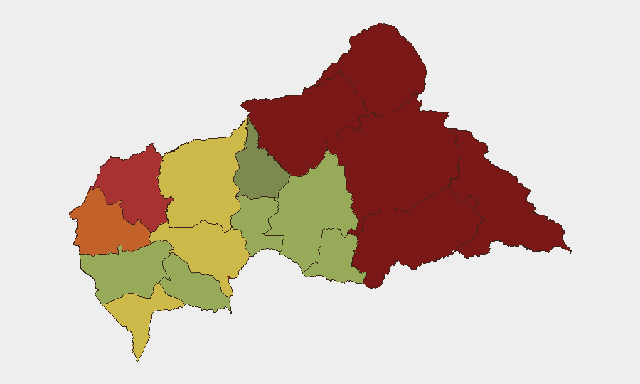
Vakaga (95), Bamingui-Bangoran (92), and Haute-Kotto (88) in the northeast remain the critical focal points, driven by sustained FPRC activity, contested territory, and limited state presence. Haut-Mbomou and Mbomou in the southeast present similar risks, with porous DRC borders enabling cross-border armed group incursion and trafficking. Bangui itself (78) and Ouham-Pendé (79) carry elevated risk from criminal activity, community tensions, and periodic armed group presence in surrounding hinterlands. The western and southern regions (Sangha-Mbaéré, Ouham, Ombella-M'Poko, Kémo) remain comparatively more stable but are not immune to outbreaks of localized violence or criminal activity.
How GeoBit Would Assist
Security teams operating or with personnel in CAR should employ AOI Monitoring & Early Warning to track conflict activity and armed-group movement in high-risk prefectures (particularly Vakaga, Bamingui-Bangoran, and the DRC frontier zones) with persistent alerting on battles, checkpoints, and force deployments. Network & Actor Analysis combined with multi-language OSINT (including Telegram and local radio SIGINT) would provide real-time visibility on rebel faction positioning, coordination, and supply-line movements. Routing & Network Analysis enables generation of current alternative travel corridors and risk-adjusted journey planning, especially critical given the new CAR–DRC border enforcement posture.
7-Day Outlook
The next week will likely see consolidation of the CAR–DRC border cooperation framework, with increased military visibility along frontier crossing points and potential for temporary travel delays. Vakaga and Bamingui-Bangoran remain flash-point zones for renewed FPRC–FACA clashes. Broader national security conditions are expected to remain tense but not to escalate dramatically absent new cross-border incursions or major urban destabilization.
Highest-Risk Areas — Ranked
| # | State / Region | Risk |
|---|---|---|
| 1 | Vakaga | 95 |
| 2 | Bamingui-Bangoran | 92 |
| 3 | Haute-Kotto | 88 |
| 4 | Haut-Mbomou | 85 |
| 5 | Mbomou | 82 |
| 6 | Ouham-Pendé | 79 |
| 7 | Bangui | 78 |
| 8 | Nana-Mambéré | 75 |
| 9 | Sangha-Mbaéré | 68 |
| 10 | Ouham | 65 |
| 11 | Ombella-M'Poko | 62 |
| 12 | Kémo | 58 |
Sources
Previous Daily Briefs
A new Central African Republic brief is written every day — each with its own risk map and downloadable CSV. Here's the last week; use the calendar to go further back.
- August 26, 2026
- August 25, 2026
- August 24, 2026
- August 23, 2026
- August 21, 2026
- August 20, 2026
- August 19, 2026
📅 Browse every day by calendar →
Highlighted days have a brief. Tap a day for that day's map & analysis, or “csv” for that day's dataset ($5).
Atlas — our AI intelligence desk — emails them this snapshot personally. Nothing else, no list.