Situation Summary
Central African Republic remains in a fragile security equilibrium with persistent armed-group activity, particularly in border regions and the northeast. The composite national threat score of 65 (rank #33 globally) reflects ongoing conflict dynamics rather than acute escalation; however, sub-national risk is heavily concentrated in the Vakaga, Bamingui-Bangoran, and Haute-Kotto prefectures. Recent weeks have seen localized clashes, humanitarian displacement, and mining-sector instability, while international peacekeeping presence has been reinforced.
Key Developments
- 28 August 2026 – Haut-Mbomou displacement update: OCHA/RJDH reporting confirmed 3,655 internally displaced persons across localities in the Zemio–Dembia axis (Tabane, Bogou, Bangassou-Issa, Barh, Guinikoumba) stemming from armed-group abuses following the June killing of Guinikoumba village chief. This represents an ongoing humanitarian consequence of earlier violence rather than a new discrete incident.
- Status quo on 24–27 August events: The FPRC-affiliated attack on a Vakaga locality (24 August) and the Zamboye mine closure (22 August, following the 20 August landslide killing 49–100+ miners near Baboua, Nana-Mambéré) remain the most recent documented security/safety events. No new armed clashes, mass-casualty incidents, or major civil unrest have been clearly sourced to 28–29 August in available open reporting.
- Border-security coordination ongoing: The 21 August CAR–DRC military intelligence agreement targeting the 1,600 km shared frontier continues to shape regional security posture; the 27 August deployment of Cambodia's 12th peacekeeping batch (184 personnel) to MINUSCA reinforces stabilization efforts but does not alter immediate threat trajectory.
Highest-Risk Areas
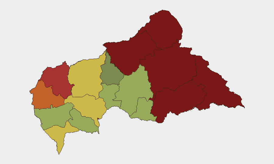
Vakaga (risk 95) and Bamingui-Bangoran (risk 92) remain critical vulnerability zones, driven by proximity to Sudan and Chad borders, armed-group sanctuary corridors, and limited state capacity. Haute-Kotto (88), Haut-Mbomou (85), and Mbomou (82) in the southeast present secondary but substantial risks, amplified by ongoing displacement, trafficking networks, and resource-extraction conflicts. Bangui (78) concentrates urban security challenges including criminality and factional tensions. The northeastern and eastern prefectures collectively account for the highest composite threat scores and should remain priority areas for corporate and diplomatic duty-of-care monitoring.
How GeoBit Would Assist
Security teams managing personnel or assets in CAR should employ AOI Monitoring & Early Warning on high-risk prefectures (Vakaga, Bamingui-Bangoran, Haut-Mbomou) with persistent alerting on armed-group activity, displacement events, and border crossings. Intel Sweep, multi-language OSINT, and X/Telegram signal monitoring provide real-time event corroboration and actor-movement tracking to fill gaps in official reporting. Conflict & Military mapping and Network & Actor Analysis support identification of FPRC and rival faction movements, while Satellite & Imagery analysis can monitor mining zones and IDP settlement perimeters for sudden changes in activity or humanitarian access.
7-Day Outlook
No imminent major escalation is signaled by current open reporting; however, the fragmented security environment and armed-group presence in border zones create persistent risk of localized clashes and civilian harm. Continued monitoring of Vakaga, mining-area incidents, and displacement flows is warranted. Any new cross-border incursion or factional violence in Bangui could rapidly elevate the threat picture.
Highest-Risk Areas — Ranked
| # | State / Region | Risk |
|---|---|---|
| 1 | Vakaga | 95 |
| 2 | Bamingui-Bangoran | 92 |
| 3 | Haute-Kotto | 88 |
| 4 | Haut-Mbomou | 85 |
| 5 | Mbomou | 82 |
| 6 | Ouham-Pendé | 79 |
| 7 | Bangui | 78 |
| 8 | Nana-Mambéré | 75 |
| 9 | Sangha-Mbaéré | 68 |
| 10 | Ouham | 65 |
| 11 | Ombella-M'Poko | 62 |
| 12 | Kémo | 58 |
Sources
Previous Daily Briefs
A new Central African Republic brief is written every day — each with its own risk map and downloadable CSV. Here's the last week; use the calendar to go further back.
- August 27, 2026
- August 26, 2026
- August 25, 2026
- August 24, 2026
- August 23, 2026
- August 21, 2026
- August 20, 2026
📅 Browse every day by calendar →
Highlighted days have a brief. Tap a day for that day's map & analysis, or “csv” for that day's dataset ($5).
Atlas — our AI intelligence desk — emails them this snapshot personally. Nothing else, no list.