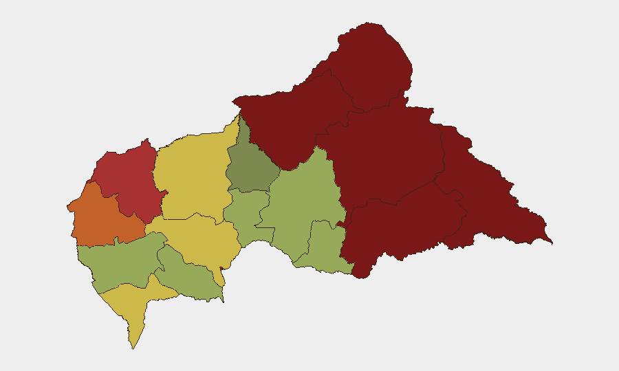
Situation Summary
Central African Republic remains at composite threat level 33 globally (score 65), driven primarily by active armed conflict in peripheral prefectures. The security environment is characterized by fragmented rebel activity, criminal predation on civilian populations, and limited state capacity outside Bangui. No major new incidents have been documented in the last 24–48 hours; however, the recent mining disaster in Nana-Mambéré (20 August) and armed clashes in northeastern Vakaga and Mbomou (17–24 August) underscore ongoing volatility in high-risk zones.
Key Developments
- No corroborated security incidents in Central African Republic have been documented in the last 24–48 hours (29–30 August 2026) that meet reporting thresholds. Open-source coverage from 29–30 August consists primarily of routine deportation flights to Bangui and general police-harassment allegations, neither indicating acute conflict or civil unrest.
- Regional context (Niger instability): Armed mutiny and street fighting have been reported in Niamey, Niger on 29–30 August 2026, with clashes near the presidency, air base, and airport. While cross-border spillover into CAR has not yet been confirmed, monitoring of Bangui–Niamey transport corridors and northern Ouham prefecture is warranted in coming days.
- Recent precedent in high-risk zones (last 7 days): FPRC-affiliated forces conducted deadly assaults in Vakaga (24 August); joint Russian-FACA operations in Mbomou and Ouham-Pendé resulted in clashes and detentions (17 August); armed groups committed mass abuses on the Zemio–Dembia axis in Haut-Kotto (26 August, displacement ongoing).
Highest-Risk Areas
Vakaga (risk 95) and Bamingui-Bangoran (risk 92) in the far northeast remain the most destabilized prefectures, driven by FPRC and other rebel group presence and active military operations. Haut-Kotto (88) and eastern Mbomou (82) are secondary nodes of high risk, marked by banditry and armed-group exactions against civilians. Bangui itself (risk 78) is elevated primarily by criminal gang activity and limited police capacity rather than organized armed conflict; however, it remains the critical node for evacuation and service continuity. The pattern reflects a "hollow state" geography: armed actors dominate peripheral zones where MINUSCA and FACA presence is thin, while Bangui and southwestern prefectures are relatively more stable.
How GeoBit Would Assist
Corporate teams with personnel or assets in CAR should employ AOI Monitoring & Early Warning to track high-risk prefectures (Vakaga, Bamingui-Bangoran, Haut-Kotto) with persistent alerting on clashes, displacement, and armed-group movements. Conflict & Military battle mapping and force-structure tracking can clarify FPRC, NOUREDDINE, and allied militia positions and operational tempo to inform travel-restriction and relocation decisions. Routing & Network Analysis can model alternative air and ground corridors around active conflict zones and validate safe passage planning for Bangui to regional hubs, particularly given Niger volatility.
7-Day Outlook
The immediate security trajectory for CAR is likely to remain consistent with the last 2–4 weeks: episodic armed clashes in the northeast and east, criminal activity in Bangui, and limited overall escalation. However, instability in Niger may trigger refugee flows and cross-border armed-group repositioning within 7–14 days; northern CAR prefectures (Ouham, Ouham-Pendé, Vakaga) should be monitored for secondary effects. No major new conflict initiation is expected in this window, but duty-of-care teams should assume current high-risk zones remain inaccessible and maintain contingency postures for non-essential personnel.
Highest-Risk Areas — Ranked
| # | State / Region | Risk |
|---|---|---|
| 1 | Vakaga | 95 |
| 2 | Bamingui-Bangoran | 92 |
| 3 | Haute-Kotto | 88 |
| 4 | Haut-Mbomou | 85 |
| 5 | Mbomou | 82 |
| 6 | Ouham-Pendé | 79 |
| 7 | Bangui | 78 |
| 8 | Nana-Mambéré | 75 |
| 9 | Sangha-Mbaéré | 68 |
| 10 | Ouham | 65 |
| 11 | Ombella-M'Poko | 62 |
| 12 | Kémo | 58 |
Sources
Previous Daily Briefs
A new Central African Republic brief is written every day — each with its own risk map and downloadable CSV. Here's the last week; use the calendar to go further back.
- August 29, 2026
- August 27, 2026
- August 26, 2026
- August 25, 2026
- August 24, 2026
- August 23, 2026
- August 21, 2026
📅 Browse every day by calendar →
Highlighted days have a brief. Tap a day for that day's map & analysis, or “csv” for that day's dataset ($5).
Atlas — our AI intelligence desk — emails them this snapshot personally. Nothing else, no list.