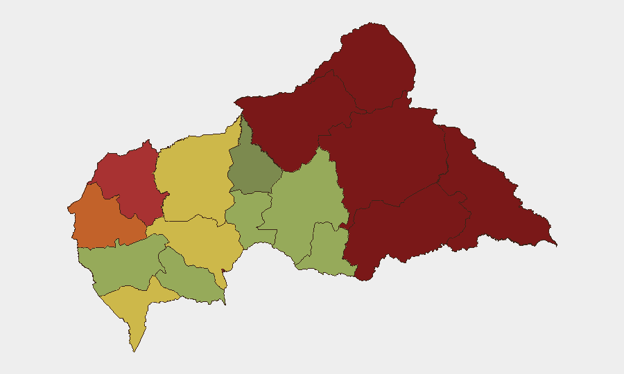
Situation Summary
Central African Republic remains in active conflict with composite threat score 65 (rank #33 globally), driven primarily by ongoing civil war, rebel faction activity, and localized militia operations. As of late August 2026, security conditions are characterized by persistent armed group presence in border and southeastern prefectures, with civilian protection challenges limiting humanitarian access. The country's mining sector has been disrupted by industrial disaster, compounding economic stress in an already fragile operating environment. No major new discrete security incidents have been confirmed for the last 24–48 hours (Aug 31–Sep 1), though baseline threat conditions remain elevated.
Key Developments
No verified, multi-source-confirmed discrete security incidents in Central African Republic have been identified for Aug 31–Sep 1, 2026 in available open-source reporting. Recent material references ongoing conditions rather than new dated events:
- Vakaga Prefecture (border region): Analytical reporting dated Aug 31, 2026 indicates security forces on high alert following earlier assaults by armed factions, with possible regrouping and renewed offensive activity near Am-Dafock (CAR–Sudan border), though no specific new clash has been dated to the last 48 hours.
- Haut-Mbomou Prefecture (southeast): UNHCR operational update (Aug 31, 2026) confirms continued localized threat from Azande Ani Kpi Gbe (AAKG) militia, constraining state authority and humanitarian access—assessed as persistent threat rather than acute new incident.
- Bangui (capital): U.S. deportation flight landed Aug 30, 2026 with Afghan and other deportees, generating diplomatic/human-rights commentary but no reported security incident or civil unrest linked to the arrival.
- General pattern: Humanitarian and analytical sources (UNHCR, weekly geopolitical reports, Aug 31) describe "intense militia activity and inter-community violence" in multiple locations, but without specific time-stamped incidents for Sep 1, 2026.
Note: Most recent dated events in GeoBit's event signals (Aug 17–28) reflect battles near Yemen/Mbomou and Pendere/Ouham-Pendé prefectures, FPRC seizure in Vakaga, and violence against civilians in multiple villages. These remain operationally relevant for risk assessment but predate the 24–48-hour window.
Highest-Risk Areas
Vakaga Prefecture (risk 95) and Bamingui-Bangoran (92) represent the highest acute threats, driven by rebel faction activity (particularly FPRC regrouping) and cross-border insecurity near Sudan. Haute-Kotto (88) and Haut-Mbomou (85) follow, with militia presence and humanitarian access constraints elevating risk to civilians and international operations. These four prefectures account for a significant share of armed-group incidents and represent the primary zones where organizations should expect heightened exposure to armed confrontation, arbitrary detention, and banditry. Bangui itself (risk 78) remains elevated due to urban criminality, residual political volatility, and the presence of multiple armed actors, though it retains greater state presence than remote prefectures.
How GeoBit Would Assist
Security teams operating in or planning movement through CAR should employ Area-of-Interest Monitoring & Early Warning for specific prefectures (Vakaga, Bangui, Haut-Mbomou) to detect discrete incidents and militia repositioning in near-real-time. Routing & Network Analysis would identify safer transit corridors and alternative logistics pathways, essential given ongoing clashes and extortion by armed groups. Network & Actor Analysis combined with OSINT fusion (X/Telegram monitoring, local-language intelligence) can track FPRC, AAKG, and bandit-group communications to anticipate violence against civilians and supply-chain disruption.
7-Day Outlook
Insecurity in Vakaga and border areas is likely to persist or intensify through early September, with rebel regrouping suggesting continued tactical activity. Humanitarian access constraints and localized militia operations in Haut-Mbomou are forecast to remain steady-state absent a major shift in armed-group coordination or state capacity. Organizations should maintain elevated vigilance and contingency protocols for rapid staff relocation if clashes expand into or near urban centers.
Highest-Risk Areas — Ranked
| # | State / Region | Risk |
|---|---|---|
| 1 | Vakaga | 95 |
| 2 | Bamingui-Bangoran | 92 |
| 3 | Haute-Kotto | 88 |
| 4 | Haut-Mbomou | 85 |
| 5 | Mbomou | 82 |
| 6 | Ouham-Pendé | 79 |
| 7 | Bangui | 78 |
| 8 | Nana-Mambéré | 75 |
| 9 | Sangha-Mbaéré | 68 |
| 10 | Ouham | 65 |
| 11 | Ombella-M'Poko | 62 |
| 12 | Kémo | 58 |
Sources
Previous Daily Briefs
A new Central African Republic brief is written every day — each with its own risk map and downloadable CSV. Here's the last week; use the calendar to go further back.
- August 31, 2026
- August 30, 2026
- August 29, 2026
- August 27, 2026
- August 26, 2026
- August 25, 2026
- August 24, 2026
📅 Browse every day by calendar →
Highlighted days have a brief. Tap a day for that day's map & analysis, or “csv” for that day's dataset ($5).
Atlas — our AI intelligence desk — emails them this snapshot personally. Nothing else, no list.