Situation Summary
Central African Republic remains classified as #33 globally in composite threat severity (score 65), with armed group activity, criminal violence, and recent mining disasters driving elevated risk across multiple prefectures. The country faces concurrent pressures: renewed FPRC (Noureddine Adam faction) activity in the northeast, ongoing banditry and civilian exactions in central and eastern zones, and critical supply-chain disruption following the 20 August Baboua gold mine landslide. Security conditions are deteriorating in key eastern and northern prefectures, while humanitarian access constraints persist.
Key Developments
- No verified, dated incidents from 2026-09-01 to 2026-09-02 have been corroborated from available open sources. GeoBit's live web research (last 24 hours) returned no CAR-specific security events with confirmed timestamps within this window.
- Baboua gold mine landslide (20 August) — economic and supply-chain impact ongoing: The incident killed 49–100+ miners and triggered closure of the Zamboye mine on 22 August, creating cascading disruption to artisanal and commercial mining sectors and local livelihoods. Recovery timelines remain unclear.
- FPRC seizure in Vakaga Prefecture (24 August): Armed men affiliated with the FPRC (Noureddine Adam faction) executed a deadly assault and captured a locality in the highest-risk prefecture, signaling renewed factional military capability and territorial ambition in the northeast.
- Civilian exactions and abductions (28 August): Armed groups committed multiple abductions, extortion, and violence incidents against civilian populations in Guinikoumba and villages along key routes, indicating intensified predatory activity against non-combatants.
- Joint FACA–Russian operations (17 August, Mbomou and Ouham-Pendé): Patrols near Yemen settlement (Mbomou) and north of Pendere village (Ouham-Pendé) engaged and eliminated small illegal armed cells, reflecting ongoing counterinsurgency operations but also persistent armed group presence near populated areas.
Highest-Risk Areas
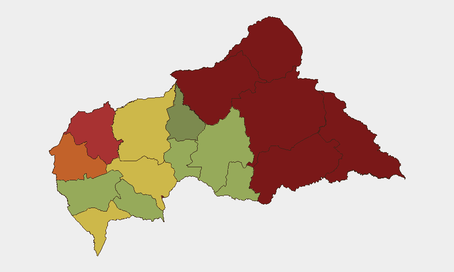
Vakaga Prefecture (risk 95) and Bamingui-Bangoran (risk 92) in the far north and northeast drive the country's highest composite scores, reflecting FPRC territorial control, porous borders with Chad and Sudan, and disrupted humanitarian logistics. Haute-Kotto, Haut-Mbomou, and Mbomou prefectures (risks 88, 85, 82 respectively) remain volatile due to ongoing banditry, armed group recruitment, and civilian victimization. Bangui itself (risk 78) and surrounding Ombella-M'Poko remain under formal state control but experience sporadic criminal violence and political tension. Eastern and northern zones pose the greatest risk to corporate and humanitarian personnel.
How GeoBit Would Assist
Organizations operating in or supporting Central African Republic should deploy AOI Monitoring & Early Warning capabilities on Vakaga, Bamingui-Bangoran, and key mining zones to detect armed group movements and supply-route disruptions in real time. Conflict & Military battle mapping and force-structure tracking provide visibility into FACA disposition, Russian specialist positioning, and FPRC faction movements to support route planning and personnel safety assessments. Routing & Network Analysis combined with humanitarian & NGO data feeds enable identification of safe corridors and supply alternatives in the face of ongoing closures and armed group exactions.
7-Day Outlook
Armed group activity is expected to remain elevated in northeastern prefectures (Vakaga, Bamingui-Bangoran) through mid-September, with FPRC factions likely testing state security responses. Mining sector disruption will persist, constraining both economic recovery and local population stability. Humanitarian access constraints and civilian exactions along transport routes will continue to present acute risks to field operations and supply chains.
Highest-Risk Areas — Ranked
| # | State / Region | Risk |
|---|---|---|
| 1 | Vakaga | 95 |
| 2 | Bamingui-Bangoran | 92 |
| 3 | Haute-Kotto | 88 |
| 4 | Haut-Mbomou | 85 |
| 5 | Mbomou | 82 |
| 6 | Ouham-Pendé | 79 |
| 7 | Bangui | 78 |
| 8 | Nana-Mambéré | 75 |
| 9 | Sangha-Mbaéré | 68 |
| 10 | Ouham | 65 |
| 11 | Ombella-M'Poko | 62 |
| 12 | Kémo | 58 |
Sources
Previous Daily Briefs
A new Central African Republic brief is written every day — each with its own risk map and downloadable CSV. Here's the last week; use the calendar to go further back.
- September 1, 2026
- August 31, 2026
- August 30, 2026
- August 29, 2026
- August 27, 2026
- August 26, 2026
- August 25, 2026
📅 Browse every day by calendar →
Highlighted days have a brief. Tap a day for that day's map & analysis, or “csv” for that day's dataset ($5).
Atlas — our AI intelligence desk — emails them this snapshot personally. Nothing else, no list.